Flow-Tub: a computationally efficient large-scale flood mapping model

Posted by Indraneel Kasmalkar
With global climate change and sea level rise, we see more and more news of coastal storms and floods around the world. To understand the potential impacts of such events, cities and states are turning to flood risk analysis. The procedure is straightforward: overlay flood maps onto maps of the built environment and estimate potential damage costs.
The challenge lies in developing accurate flood maps, especially for unprecedented extreme events. Hydrodynamic models are the gold standard – they solve the fluid dynamics equations to project how far inland water would run during a storm and how high the water level would be. However, these models are computationally intensive and may take unreasonably long run times for large coastlines. The problem is compounded for probabilistic risk analyses where thousands of potential flood events may need to be simulated.
A simpler approach is to use bathtub inundation models. Here, a specific water level is chosen, and areas which lie below that level are deemed as flooded. While this method is straightforward, it can lead to significant false positives, marking areas as flooded where the water might not be able to reach due to geographic constraints. Additionally, the method does not account for surface friction or for the limited durations of storms.
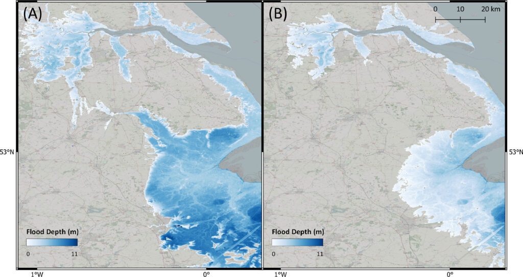
Floods maps for Hull, United Kingdom generated by (A) the standard bathtub model (left) and (B) the Flow-Tub model (right). The results demonstrate that connectivity and path-based attenuation reduce flood extents and volumes compared to standard bathtub models. See Figure 8 from the article.
To improve coastal flood mapping, we present the Flow-Tub model. It marries the computational efficiency of bathtub models with additional hydrodynamic processes to improve accuracy. The Flow-Tub model starts by inundating low-lying areas at the coastline, and then sequentially moves inward, identifying flooded areas while accounting for water level attenuation and feasibility of flow propagation. While it does not solve the full fluid dynamics equations, our findings show that it substantially improves upon the shortcomings of the bathtub model, resulting in over 20% reduction in total flooded area over the latter. A Flow-Tub model allows us to better estimate global flood costs as we enter an era of higher sea levels and more intense storms.
This research was funded by the Ministry of Education, Singapore (grant no. MOE 2019-T3-1-004) and by the National Research Foundation, Prime Minister’s Office, Singapore under the NRF-NRFF2018-06 award. For detailed information about the Flow-Tub model, check out the full article, published in MethodsX.
Full article citation:
Indraneel Kasmalkar, Dennis Wagenaar, Alina Bill-Weilandt, Jeanette Choong, Sonali Manimaran, Tian Ning Lim, Maricar Rabonza, David Lallemant, Flow-tub model: A modified bathtub flood model with hydraulic connectivity and path-based attenuation, MethodsX, Volume 12, 2024, 102524, ISSN 2215-0161, https://doi.org/10.1016/j.mex.2023.102524.
Dr. Indraneel Kasmalkar is a Research Fellow in the Disaster Analytics for Society Lab. He works at the intersection of climate, mathematics, and computation, where he develops high performance computing models for quantifying physical climate risk.
Keywords:
Coastal flooding; Bathtub model; Connectivity; Attenuation; Climate change