Waiting for the Big One: the Continued Earthquake Risk of Port-au-Prince, Haiti.
This post is transcribed from a paper presented at the 3rd International Conference on Urban Disaster Recovery (3ICUDR).
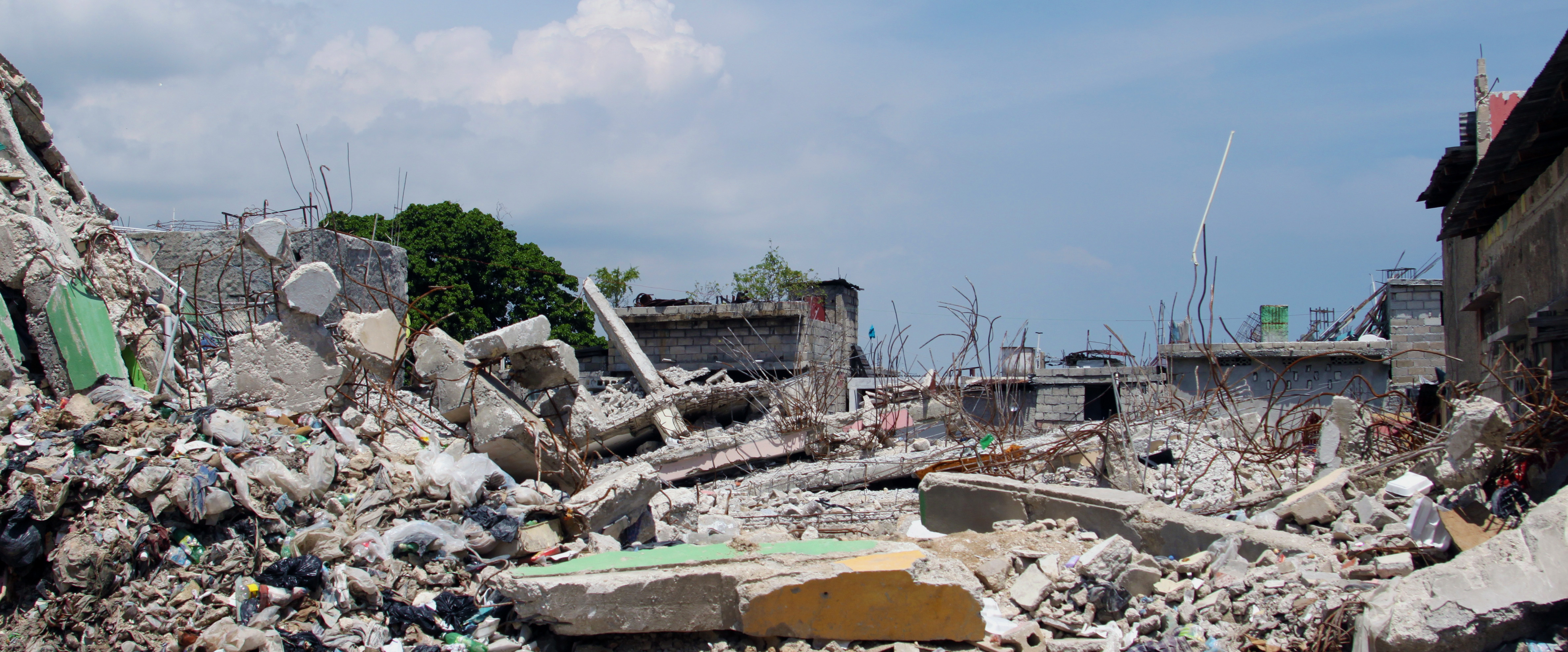
The M7.0 earthquake in Haiti in 2010 was one of the most devastating in recorded history. Due to its proximity to Port-au-Prince and the extreme vulnerability of buildings, the earthquake led to the death of 150,000-220,000 people. Yet the so-called “Port-au-Prince earthquake” should more aptly be named “Leogane earthquake,” as evidence suggests that the Port-au-Prince earthquake has not yet occurred. Indeed geologic, geodedic and seismologic studies have shown that the 2010 earthquake occurred along a blind thrust fault in the Leogane plain, not along the Enriquillo-Plantain Garden Fault (EPGF) where it was expected [1-4]. Field-work conducted by USGS in 2010 and 2012 has further provided clear evidence that the EPGF did not participate in the 2010 rupture (hence no or little energy was released in that system), yet that it has experienced significant and repeated surface ruptures in the recent geological past [5, 6].
This geological and paleoseismic evidence provides a sobering counter-argument to the general belief that the region can confidently look forward to a period of earthquake tranquility in the coming decades. In fact, Port-au-Prince was destroyed by an earthquake in 1751, and destroyed again by another in 1770. This clustering of earthquakes is not unusual, and some have suggested that the 2010 earthquake could mark the beginning of a new cycle of seismic activity on the Enriquillo fault system [12]. Extending along the entire southern edge of Port-au-Prince, the expected rupture of the Enriquillo-Plantain Garden Fault has the potential to generate significant earthquakes, causing damage comparable, and possibly much worse, than that resulting from the 2010 earthquake. However, the author’s experience from two years of work in Haiti following the 2010 earthquake suggests that this extreme risk is not part of the awareness of the decision-makers (local and international) nor the general public in Haiti. This study describes the potential impact of the expected rupture of the EPGF, to serve as additional evidence and advocacy for earthquake risk reduction in Port-au-Prince.
Scenario Earthquake and Hazard Model
The rupture scenario used in this study is based on and consistent with field studies conducted by the United States Geological Survey (USGS) in 2010 and 2012 in collaboration with the Haitian Bureau of Mines and Energy. These field studies yielded two main observations. First, that the 2010 rupture occurred along a blind thrust fault beneath the Leogane plain, with little to no rupture of the EPGF. This observation was corroborated by several other studies [2, 7]. The second is that the EPGF has undergone large and repeated ruptures in its recent geologic past.
This sets the premise for a scenario earthquake of M7.0 caused by the rupture of a 40km segment of the EPGF. This scenario is of course hypothetical, but nonetheless realistic and plausible given the current knowledge of the EPGF and its seismic history.
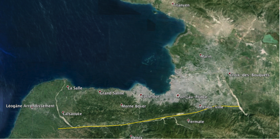
Figure 1. Trace of the hypothetical rupture of a 40km segment of the Enriquillo-Plantain Garden Fault. (Image from Google Earth, 2014 DigitalGlobe)
From this source model, ground-motion intensity fields for Peak Ground Acceleration are generated using the Boore-Atkinson 2008 ground motion prediction model [8]. For every simulation, PGA values are simulated at every site such that sites close to each other have correlated intensity which decays with distance, according to the spatial correlation model developed by Jayaram and Baker [9].

Figure 2. Examples of spatially correlated earthquake ground-motion intensity fields necessary to compute risk at the urban or regional scale.
Building Inventory & Fragility Model
The exposure model used in this study is based on the building inventory collected by the Haitian Ministry of Public Works as part of the post-disaster building damage assessment [10]. This inventory includes all buildings in Port-au-Prince metropolitan area as well as neighboring cities, totaling over 400,000 buildings categorized by structural type, wall type, number of floors and other relevant attributes. This same inventory is used to develop the earthquake fragility models for buildings. In this case-study, the metric of interest is the total number of buildings collapsed, since this is most directly related to the number of fatalities. Two approaches are used to model the collapse fragility of buildings. In the first, standard lognormal fragility curves are developed for every structural type using the building damage assessment results as well as predicted ground motion intensity developed for the 2010 fault rupture model [11]. In the second, a multivariate generalized linear model is developed, which uses other building attributes such as infill type, number of floors, and other attributes relevant for collapse. This maximizes the utility of the damage survey data, reduces the uncertainty on the predicted results, and increases the resolution of predicted damage. Based on the post-disaster field assessment, the model therefore represents a very realistic representation of the actual building inventory and earthquake fragility of buildings at the time of the 2010 earthquake. It is noted that this building inventory has changed significantly since the earthquake occurred. In particular, approximately 30,000 buildings collapsed during the earthquake, and hence are no longer in this inventory. In addition, many new buildings have been constructed in a large spontaneous urban expansion to the North of the city. However the same inventory is used in order to make the results more directly comparable.
Scenario Results
The figures below shows the distribution of collapsed buildings, comparing the real distribution during the 2010 earthquake, with that predicted from the EPGF rupture scenario.
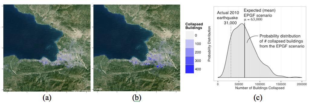
Figure 3. Spatial distribution of buildings collapsed from (a) the actual 2010 earthquake, (b) predicted based on the EPGF rupture scenario. (c) Probability distribution of number of buildings collapsed from the EPGF rupture scenario (mean = 63,000 buildings), compared with the actual 2010 earthquake (31,000 buildings).
Conclusion
While there is a general belief that the Port-au-Prince area can look forward to a period of seismic quiescence following the 2010 earthquake, the existing geological, seismological and historical evidence does not support this. However, as in many places around the world, the hazard evidence by itself has received little traction for promoting risk reduction actions. Since real data forms the basis for both fragility and exposure models, this scenario provides a very realistic example of potential damages caused by the expected “Port-au-Prince earthquake.” The scenario demonstrates that this event, linked with the rupture of the Enriquillo-Plantain Garden Fault, has the potential to cause much more severe damage even then the 2010 “Leogane earthquake.” Preliminary results are estimated at twice the number of buildings collapsed. The hazard model is hypothetical and its impact has significant uncertainty (see distribution in Figure 3c). But while this exact event will not actually occur, the scale/location of the earthquake and the scale of the impact are plausible and consistent with existing knowledge of the seismicity, exposure and vulnerability of the area. It is clear therefore that efforts should be intensified to promote earthquake risk reduction in Port-au-Prince, both through the reconstruction process as well as long term municipal planning.
References
1. Hayes G Finite Fault Model: Updated Result of the Jan 12, 2010 Mw 7.0 Haiti Earthquake. In: National Earthquake Information Center (NEIC) of United States Geological Survey. http://earthquake.usgs.gov/earthquakes/eqinthenews/2010/us2010rja6/finite_fault.php. Accessed 30 Mar 2014
2. Calais E, Freed A, Mattioli G, et al. (2010) Transpressional rupture of an unmapped fault during the 2010 Haiti earthquake. Nature Geosci 3:794–799. doi: 10.1038/ngeo992
3. Prentice CS, Mann P, Crone AJ, et al. (2010) Seismic hazard of the Enriquillo–Plantain Garden fault in Haiti inferred from palaeoseismology. Nature Geosci 3:789–793. doi: 10.1038/ngeo991
4. Briggs RW, Hayes GP, Sladen A, et al. (2010) Complex rupture source of the 12 January 2010 Léogâne, Haiti earthquake derived from geologic, geodetic, and seismologic observations. AGU Fall Meeting Abstracts -1:0004.
5. Gold RD, Prentice CS, Crone AJ, et al. (2012) Evidence of multiple, prehistoric, ground-rupturing earthquakes along the Enriquillo-Plantain Garden Fault system near Port-au-Prince, Haiti. AGU Fall Meeting Abstracts -1:2573.
6. Prentice CS, Crone AJ, Gold RD, et al. (2012) Seismic Hazard in Haiti: A Geologic Perspective. AGU Fall Meeting Abstracts -1:03.
7. Douilly R, Haase JS, Ellsworth WL, et al. (2013) Crustal Structure and Fault Geometry of the 2010 Haiti Earthquake from Temporary Seismometer Deployments. Bulletin of the Seismological Society of America 103:2305–2325. doi: 10.1785/0120120303
8. Boore DM, Atkinson GM (2008) Ground-Motion Prediction Equations for the Average Horizontal Component of PGA, PGV, and 5%-Damped PSA at Spectral Periods between 0.01 sand 10.0 s. Earthquake Spectra 24:99–138. doi: 10.1193/1.2830434
9. Jayaram N, Baker J (2009) Correlation model for spatially distributed ground-motion intensities. Earthquake Engng. Struct. Dyn.
10. MTPTC (2010) Evaluation des Batiments. In: Ministere des Travaux Publics, Transports et Communications. http://www.mtptc.gouv.ht/accueil/actualites/article_7.html. Accessed 10 Apr 2013
11. USGS Mag 7.0 Earthquake – Haiti Region. In: earthquake.usgs.gov. http://earthquake.usgs.gov/earthquakes/eqinthenews/2010/us2010rja6/. Aug 2013
12. Bakun WH, Flores CH, Brink ten US (2012) Significant Earthquakes on the Enriquillo Fault System, Hispaniola, 1500-2010: Implications for Seismic Hazard. Bulletin of the Seismological Society of America 102:18–30. doi: 10.1785/0120110077
2 Responses
Hello David,
First of all, I’d like to congratulate you on this interesting research.
I’m a PhD student at the Technical University of Madrid (Spain) and work on the same line: seismic hazard and risk in Haiti. I totally agree with your hypothesis of a M 7.0 future plausible earthquake happening close to Port-au-Price and have estimated the associated risk scenario. My results seem to be consistent with yours. Actually, I also work with the same database (the one compiled by the Ministry of Public Works of Haiti).
I have followed the analytical method to compute the damage probabilities, using capacity spectra that we calibrated with damage data from the 2010 earthquake (published as Molina, Torres, et al. 2014, in Bull.Earthq.Eng.).
I hope that we’ll keep in contact.
Yolanda
Hi David!
I’m Yolanda, the person who left the previous message 🙂 It’s been a while since our last Skype; I hope you’re doing great.
I’m writing to you with regard to my research on Haiti. I’m finishing my PhD Thesis and I’ve run into what I consider a “major issue”… Let me remind you very briefly: I’m applying machine learning to a building database created upon remotely sensed data. The goal is to classify the buildings into constructive typologies using only three attributes: number of stories, built area, and type of roof. I’ve tried this in Spain with success.
I need to test my results with a ground truth database, and I’m using the building database that you created in Haiti within your project after the earthquake. My problem is that I feel the version that I have is the original one, I mean, with no edition at all. So I find some inconsistencies such as incorrect area values or unlikely construction materials (according to what satellite images show).
My question is: do you have (or can I access) any building database that is refined and/or validated? If not covering the whole Port-au-Prince area, at least covering some parts.
I’m afraid I won’t be able to properly finish my PhD without a good ground truth database. And if anybody has it, this is you 🙂
Waiting for your answer…
Thank you very much in advance,
Yolanda