Remaining Earthquake Risk of Port-au-Prince, Haiti – Updated maps with Google Earth Engine
In a previous post I shared some of my research on the remaining earthquake risk of Port-au-Prince in Haiti. The main conclusion was that the earthquake which occurred in 2010 can not reasonably be assumed to be followed by a long period of earthquake tranquility. Geological and paleoseismic evidence suggests that the expected “Port-au-Prince earthquake,” (as opposed to the “Leogane earthquake” which occured in 2010), is still very much expected. I therefore conducted a simulation of the expected damage given the very plausible event of a magnitude 7.0 rupture of a 40km segment of the Enriquillo-Plantain Garden Fault (EPGF). This reasonable event would likely cause over twice the damage of the 2010 earthquake, which killed over 200,000 people. These very troubling results point to the need to take earthquake risk reduction very seriously in the reconstruction process of the city, and in all future planning processes.
I have since then put together some additional images to better demonstrate the significance of the remaining earthquake hazard. It was also an opportunity to demonstrate some of the tools I’ve been developing with Google Earth Engine. First the images and discussion, then some explanations about the process of producing them.
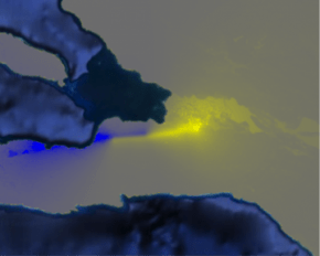
Predicted ground shaking intensity from the 2010 earthquake.
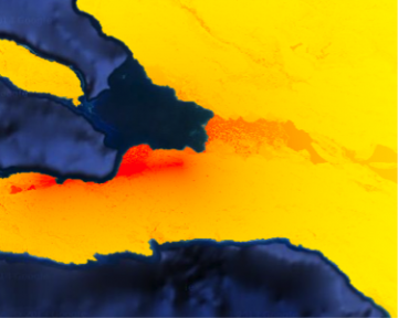
Predicted ground shaking intensity due to the rupture of the EPGF.
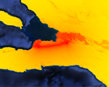
Difference in ground shaking intensity between the two scenarios above.
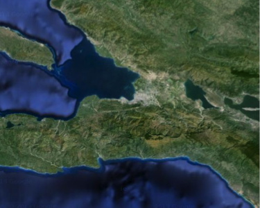
Satellite image of Haiti, showing the Port-au-Prince metropolitan area.
The images above clearly show that in the dense urban area of the Port-au-Prince metropolitan zone, the ground shaking resulting from the hypothetical (and plausible) rupture of the Enriquillo-Plantain Garden Fault segment is much more intense than the shaking predicted to have occurred during the 2010 earthquake (there were no recordings so all shaking is estimated). The third image in particular shows the difference in predicted peak ground acceleration between the two scenarios. The yellow shows areas where the shaking from the EPGF rupture is higher than that predicted from the 2010 event. This area includes virtually all the urban area of Port-au-Prince metropolitan area.
Conclusions:
- It is imperative that the reconstruction process truly sets the path towards safer building construction in Port-au-Prince, and in the rest of the country where the earthquake hazard is high.
- To all my friends who are still working on reconstruction in Haiti (yes there is still lots of work to be done, as expected from any major disaster), please get your house assessed by an engineer who knows about seismic design. Take their advise seriously (I know this is hard to do), and change homes if you need. Get your organizations to evaluate each of their offices and staff housing as well. I know that many sophisticated organizations (who should know better!) have failed to do this.
A note on the analysis with Google Earth Engine:
In order to produce these maps I used a new-ish tool produced by google called Earth Engine. It is essentially an enormous repository of geospatial data, as well as an analysis platform for that data (petabytes of data and thousands of servers for analysis!). A colleague and I were awarded a Google Research Award to use it to test out some ideas. We’re looking to use it for efficient earthquake risk analysis of cities over time. For now, I’ve used it to get predicted ground motion intensity based on an assumed fault rupture. It’s relatively simple, but Google Earth Engine enables me to do the analysis on the fly and at any resolution. It’s been very fun to play with, and I’m excited about all the other exciting applications I’ll be using it for.